
Dedicated Customer Teams & Agile Locating Services
Download
What Are Value-Added Services?
CLI offers many value-added services to provide clients with 360˚ solutions for all their project needs. These services are add-ons and are completed by both CLI and its partners. From data integration to network design, CLI makes it a priority to go above and beyond and provide comprehensive infrastructure solutions.
CLI's Value-Added Services
CLI works with a variety of partnered firms to provide additional services and cutting-edge solutions.
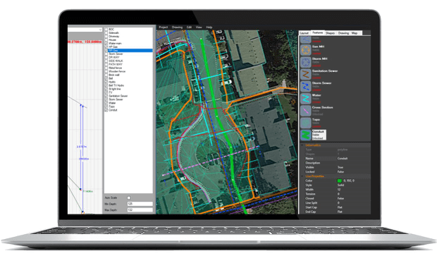
CLI can electronically map all necessary geographical elements. Using state of the art GNSS receivers to provide clients with crystal clear maps that are highly accurate and accessible.
Through the use of proprietary Web-GIS, CLI has the capacity to integrate all types of locate data, as-built information and electronic maps so that clients can have 24/7 accesses to all geospatial data. For clients with smaller IT departments and limited resources, CLI can also host all this data through their partnered network.
Once locating and mapping have been completed, CLI can use all geospatial data collected to design an interactive 3D rendering of a project. This is useful for proper visualization of conflict points, network direction and placement.
CLI has the ability to inspect sites that have been previously damaged. A technician can create a digital image of what has occurred and add it to the locate ticket.
CLI can electronically map all necessary geographical elements. Using state of the art GNSS receives to provide clients with crystal clear maps that are highly accurate and accessible.
Through the use of proprietary Web-GIS, CLI has the capacity to integrate all types of locate data, as-built information and electronic maps so that clients can have 24/7 accesses to all geospatial data. For clients with smaller IT departments and limited resources, CLI can also host all this data through their partnered network.
Once locating and mapping have been completed, CLI can use all geospatial data collected to design an interactive 3D rendering of a project. This is useful for proper visualization of conflict points, network direction and placement.
CLI has the ability to Inspect sites that have been previously damaged a technician can create a digital image of what has occurred and add it to the locate ticket.
Why Choose CLI?
Canadian Locators provides all types of utility locating services, using state of the art ground penetrating radar and electromagnetic sensors to provide clients with professionally accurate readings and utility maps. Whenever digging is to commence, CLI will ensure that locating staff are well equipped and prepared to take on any type of locating job regardless of size. All data that is collected is then professionally mapped and can be used during the permitting process.
CLI has been providing locating services all around Canada since 2001, and is recognized as a true industry leader in the field. All locating information in collected with extreme accuracy and speed, ensuring that each project can carry on as scheduled.
Experience
Accuracy
Highly Professional Staff
Mapping
CLI Total Locates 2014-2017

Providing Innovative and Professional Locating Solutions
As a diversified utility locating firm and a pioneer of cutting edge technologies, CLI is constantly evolving to provide the best client experience. CLI is one of the most awarded and well-recognized locating firms in Canada and is continually working on being the best.
Efficient
Locating
Cutting-Edge
Technologies
Cost-Saving
Processes